Geographic Information System (GIS)
What is GIS?
A Geographic Information System (GIS) is a computer-based tool utilized to capture, analyze, manage, and visualize geographic data. It integrates diverse elements, encompassing hardware, software, and data, to construct a system adept at managing spatial information effectively. GIS facilitates the exploration, interpretation, and comprehension of relationships between distinct geographical features, empowering informed decision-making across diverse industries and sectors.
Components of GIS
The components of GIS encompass:
- Hardware: This category includes computers, servers, network infrastructure, and peripheral devices like scanners and GPS receivers.
- Software: Comprising specialized applications and tools tailored for manipulating and analysing geographic data.
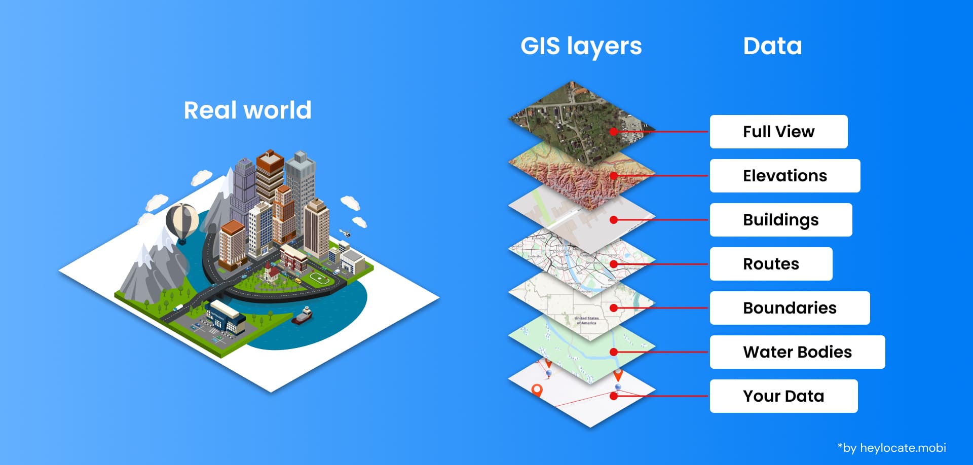
- Data: Involving the organization, storage, and retrieval of spatial information, along with the establishment and maintenance of databases.
GIS software provides functionalities for managing data, including data entry, editing, querying, and analysis. Additionally, it enables the integrating of data from varied sources such as satellite imagery, aerial photographs, and field surveys.
Essential Functions of GIS
GIS provides several core functions to facilitate effective spatial data utilization:
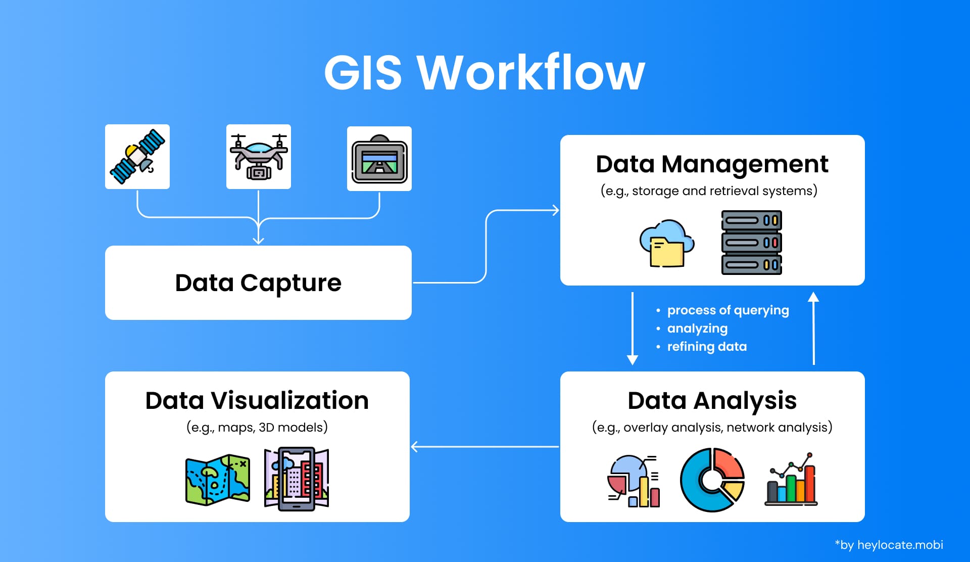
- Data Capture: GIS facilitates the collection and integration of geographic data from a myriad of sources, including satellite imagery, aerial photographs, GPS devices, and field surveys.
- Data Management: With GIS, users can efficiently manage spatial data through robust tools for organization, storage, and retrieval. Supporting a wide range of formats, including vector and raster data, GIS ensures seamless access to information when needed.
- Data Analysis: GIS empowers users to delve deep into spatial analysis, enabling tasks such as proximity analysis, overlay analysis, and network analysis. By uncovering patterns, relationships, and trends within the data, GIS facilitates informed decision-making and strategic planning.
- Data Visualization: Through GIS, users can create visually engaging maps, charts, and 3D models that effectively communicate spatial information. This visualization enhances understanding and insight into complex datasets, facilitating clearer interpretation and communication of findings.
Practical Applications of GIS
GIS has numerous practical applications across various industries and sectors. Here are some complex examples that showcase its diverse usage:
- Urban and Infrastructure Planning: GIS aids planners in comprehensively assessing ever-changing land use patterns. This allows for strategically planning vast transportation networks to accommodate population growth and optimally allocating constrained resources throughout communities.
- Holistic Environmental Management: GIS powerfully helps natural resource managers precisely map and deeply analyze intricate habitat connectivity, dynamic biodiversity shifts, and intricately interwoven ecological processes across landscapes and seascapes.
- Proactive Public Health: GIS astutely assists health departments in nimbly tracking emerging disease outbreaks, pinpointing neighborhoods at highest risk, planning effective place-based healthcare interventions, and intuitively visualizing interconnections between disease patterns, diverse demographic information and aging healthcare infrastructure to promote wellness and prevent suffering for all.
- Multi-Hazard Emergency Management: GIS is fundamentally crucial in comprehensively assessing community vulnerability to cascading risks, meticulously planning for efficient emergency response coordination across sectors, precisely mapping areas most prone to natural hazards like complex floodplains and fault zones, and identifying neighborhoods highly exposed to hazards and least prepared to withstand future disasters.
- Agriculture: GIS tracks the progress of crops in growing up and keeps them healthy. It also sends out relevant settings for water and fertilizer and sets up a plan for harvesting and logistics.
- Transportation: GIS aids in the construction of road maps and the development of practical routing options, assessing traffic and delays, and the analysis of transportation networks and infrastructure.
- Geology & Archaeology: GIS, on the other hand, maps geology and geological processes, analyzes soil and rock samples for better identification, and records archaeological sites and artifacts.
These practical applications illustrate the flexibility and wide-area effect of GIS across many domains and as a tool that helps common people make decisions and solve problems.
Advancements in GIS Technology
The growing and diversifying GIS technology has brought about enhancements that resulted in increased functionality and use in more areas. Some key advancements include:
- Web GIS: Web GIS makes use of web browsers, and this, in turn, allows greater accessibility and collaboration in Geographic Information Systems. It helps create attractive maps, data visualizations, and spatial analysis tools for any website by incorporating these tools into other media.
- Real-time GIS: A real-time GIS system enables the integration and analysis of up-to-date data streams from various sources, including sensors, GPS trackers, and social media. This advantage leads to time-certain decisions in emergency management, traffic control, and public safety.
- 3D GIS: 3D GIS brings the third dimension to the usual 2D maps and, in this way, enables more accurate and relevant data to be visualized and analyzed in space. This technology is especially rewarding in urban planning, architectural design and environmental management fields.
- Artificial Intelligence (AI) and Machine Learning (ML): Humanizing the given sentence: AI and ML systems are constantly employed together with GIS to make data analysis easier and more efficient and to increase prediction accuracy and the reliability of advanced spatial analysis. Such technologies can aid with the identification of complex patterns and relationships among many data sets, which would be difficult or tedious to detect through usual research methods.
- Big Data Integration: GIS technologies are becoming more capable of processing the continuously growing volumes of data from satellites, drones and IoT devices. Sophisticated data facilities and processing techniques lead GIS to identify and represent massive amounts of data, which discloses other insights and prospects.
- Virtual and Augmented Reality (VR/AR): VR and AR technology corridors with GIS to create immersive and interactive experiences. These technologies can be the best tools in that they compel learners to explore space in more interesting and better meaningful ways.
These geographic information systems improvements are actually increasing their application and its ability to offer correct information for making knowledgeable decisions all around the world.
References
- DeMers, Michael (2009). Fundamentals of Geographic Information Systems (4th ed.). John Wiley & Sons, inc. ISBN 978-0-470-12906-7.
- Chang, Kang-tsung (2016). Introduction to Geographic Information Systems (9th ed.). McGraw-Hill. p. 1. ISBN 978-1-259-92964-9.
- “The 50th Anniversary of GIS”. ESRI
- Geographic information system – Wikipedia
- What is GIS? | Geographic Information System Mapping Technology
- GIS (Geographic Information System)
- What is GIS? | cdc.gov